|
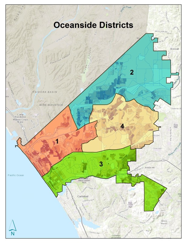
The City of Oceanside will begin the transition to District Elections in November 2018. Five community workshops were held in 2017 to determine the district boundaries, and the Oceanside City Council approved the final map at the August 1, 2017 City Council meeting. Candidates running for City Council will now be required to reside in the district they want to represent. Districts will be phased-in during the next two election cycles. Councilmembers in Districts 1 and 2 will be elected in November 2018. Councilmembers in Districts 3 and 4 will be elected in 2020. Find your district here: https://www.ci.oceanside.ca.us/gov/clerk/elections/districtelections.asp After the 2020 election, the City Council will be comprised of four City Council Members, each of whom reside in one of the established Districts, and one Mayor, who will remain elected at-large. The Mayor and City Council Members serve 4-Year terms.
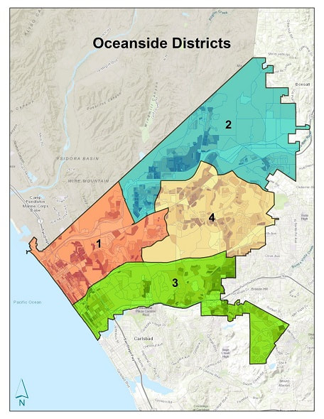
To learn more about this process, please visit the City website: https://www.ci.oceanside.ca.us/gov/clerk/elections/districtelections.asp. For questions, please email [email protected], call (760) 435-3001, or visit the City Clerk’s Office at 300 N. Coast Highway in Oceanside. Election Calendar for Districts District #1 and District #2 : 2018 District #3 and District #4 : 2020 District #1 District #1 has 40,064 residents and it runs down the coastline from the Harbor to Oceanside Blvd. The district then goes east along the Oceanside Blvd corridor, until it reaches El Camino Real. The district then continues north on El Camino Real to Mesa Drive and goes East to Rancho Del Oro Drive. Once there it continues to Highway 76 and heads back west until just before reaching Foussat Road. Then the district heads north to the Camp Pendleton border. The district then finally runs along the Camp Pendleton border back to the coastline. That is district #1. Also known as the North West District. District #2 District #2 has 40,982 residents and it begins just east of the intersection of Foussat Drive and Highway 76. Then the district continues east on Highway 76 until it reaches Douglas Drive. It then moves north along Douglas Drive to the San Luis Rey River. Then it continues east along the San Luis Rey River to College Blvd where it then heads south to Mission Avenue. It then goes East along Mission Avenue to North Santa Fe Drive where it continues South to Glenview Lane and heads East to Mission Meadows and incorporates everything else that it North East of that region within the City Limits, including the Jefferies Ranch Neighborhood and the Morro Hills Neighborhood until it reaches the Camp Pendleton Border. It will then run west along the Camp Pendleton border until it reaches just West of Fireside Park. That is district #2. Also known as the North East District. District #3 District #3 has 43,875 residents and it incorporates the entire Coastline south of Oceanside Blvd to the Carlsbad border. The district runs east along Oceanside Blvd until it reaches College Blvd. It then heads south to Olive Drive, going east to Emerald Drive and then continues south along the Oceanside Vista border until it reaches the boarder of Oceanside and Carlsbad near the Ocean Hills community. The district then continues West along the Oceanside/Carlsbad border until it reaches the Coastline. That is district #3. Also known as the Southern District. District #4 District #4 has 42,419 residents and it begins at the intersection of Oceanside Blvd and El Camino Real. It then runs east along Oceanside Blvd to College Blvd, heads south to Olive Drive and then continues east to the border of Oceanside and Vista all the way to North Santa Fe Drive. The district then heads north along North Santa Fe Drive to Mission Ave. Moves west on Mission Ave to College Blvd. It then it goes north along College Blvd to the San Luis Rey River. It then heads west along the San Luis Rey River to Douglas Drive. Then it heads South on Douglas Drive to Highway 76. It then turns back East to Rancho Del Oro. Goes South to Mesa Drive, returns back west to El Camino Real, and concludes by going south to Oceanside Blvd. That is District #4. Also known as the Central District.
Mandy Barre
6/27/2018 10:28:31 am
Who named these districts? Never saw that before now and the names certainly aren't good matches.
John Klafus
10/17/2018 12:23:31 am
The same idiots running this city into the ground
JAVIER AVILES
5/12/2020 09:27:17 am
Please proofread any city communications. it's embarrassing to read official websites with elementary school grammatical errors. Tell the writer of this website that "boarder" is someone who pays rent and lives in one's house; whereas, "border" is the demarcation between city districts. Comments are closed.
|
Categories
All
Archives
December 2023
|
|
|
|
|


 RSS Feed
